 Prestigio GeoVision Tour 7795 7" SatNav 3D European Maps


Description
The GeoVision Tour is a powerfull navigator with 3D maps and Navitel navigation software. It provides full multimedia entertainment, 3G and Wi-Fi conectivity. Stay connected and receive live traffic data, use Navitel online services, browse the web and watch movies. The GeoVision Tour is designed to be a perfect companion on the road and at home.
Award-Winning Navitel Navigation
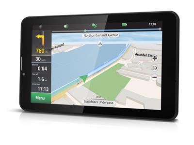
Choose one of the leading navigation software with outstanding 3D graphics and real time traffic service. Visualisation of buildings and famous landmarks in 3D will make naviagtion easier than ever. In addition, voice directons in multiple languages will keep your focus on the road, which is imperative for your safety.
Preloaded 3D Maps
Austria, Albania, Andorra, Belarus, Belgium, Bosnia and Herzegovina, Bulgaria, Croatia, Czech Republic, Denmark, Estonia, Finland, France, Germany, Gibraltar, Greece, Hungary, Iceland, Isle of Man, Italy, Latvia, Lichtenstein, Lithuania, Luxembourg, Macedonia, Malta, Moldova, Monaco, Montenegro, Netherlands, Norway, Poland, Portugal, Romania, San Marino, Serbia, Slovakia, Slovenia, Spain, Sweden, Switzerland, Ukraine, United Kingdom, Vatican. Free Lifetime Map update.
POI Database
The GeoVision Tour comes with millions of POIs pre-loaded. View Points of Interest around you and save new ones on the way. Petrol station, hotels, shops, ATMs, tourist attractions and much more.
Android Experience
Receive all the latest features that the Android has to offer you and enjoy access to the official Play Store with more than 1.5 mln apps, including the best from Google - Gmail, Drive, Photos and many more.
3-D Junction and Lane Guidance
Realistic junction views and lane instructions ensures that you make the right turn at the right time. GPS helps to prepare you for the next turn, diplaying realistic 3D pictures to indicate your designated lane.
-
POI database
The GeoVision Tour comes with millions of POIs pre-loaded. View Points of Interest around you and save new ones on the way. Petrol station, hotels, shops, ATMs, tourist attractions and much more. -
3G and Wi-Fi connectivity
Benefit from endless online possibilities which are faster with 3G and Wi-Fi connections. Receive live traffic data and save your time and money by avoiding traffic jams. -
3-D junction and lane guidance
Realistic junction views and lane instructions ensures that you make the right turn at the right time. GPS helps to prepare you for the next turn, displaying realistic 3D pictures to indicate your designated lane. -
Speed camera warning
Receive information on radars, video recording cameras and speed humps. Update the speed camera database via the internet. -
Unlimited space
The Navigator supports micro SD cards, enabling the mobility of media content.
Specifications
Summary
- Product Description
- Prestigio GeoVision Tour - GPS navigator
- Product Type
- GPS navigator
- Display
- 7" colour - 1024 x 600 pixels - widescreen
- Touch Screen
- Yes
- Input
- Touch sensitive screen (multi-touch)
- Recommended Use
- Automotive
- Preloaded Maps
- Denmark, Sweden, Norway, Italy, Finland, Switzerland, Austria, Spain, Portugal, Belgium, France, Germany, Luxembourg, Netherlands, Andorra, Liechtenstein, Slovenia, Greece, Czech Republic, Monaco, San Marino, Vatican, Gibraltar, Poland, United Kingdom, Hungary, Slovakia, Serbia, Croatia, Estonia, Bulgaria, Macedonia, Latvia, Romania, Montenegro, Lithuania, Albania, Bosnia and Herzegovina, Malta, Belarus, Moldova, Ukraine, Iceland, Isle of Man
- Interface
- USB, Bluetooth, Wi-Fi
- Internal Memory
- 4 GB
- Receiver
- SiRF Atlas V - 66 channel
- Features
- G-sensor
- Voice
- Navigation instructions
- Included Software
- Navitel
- Card Reader
- microSD, microSDHC
- Included Accessories
- Car power adapter, USB cable, cradle, 16 GB microSD Card
- Dimensions (WxDxH)
- 18.86 cm x 1.16 cm x 10.84 cm
- Weight
- 279 g
- Colour
- Black
- Manufacturer Warranty
- 1-year warranty
Detailed Specification
General
- Product Type
- GPS navigator
- Recommended Use
- Automotive
- Preloaded Maps
- Denmark, Sweden, Norway, Italy, Finland, Switzerland, Austria, Spain, Portugal, Belgium, France, Germany, Luxembourg, Netherlands, Andorra, Liechtenstein, Slovenia, Greece, Czech Republic, Monaco, San Marino, Vatican, Gibraltar, Poland, United Kingdom, Hungary, Slovakia, Serbia, Croatia, Estonia, Bulgaria, Macedonia, Latvia, Romania, Montenegro, Lithuania, Albania, Bosnia and Herzegovina, Malta, Belarus, Moldova, Ukraine, Iceland, Isle of Man
- Receiver
- SiRF Atlas V - 66 channel
- Card Reader
- microSD, microSDHC
- Interface
- USB, Bluetooth, Wi-Fi
- Voice
- Navigation instructions
- Included Software
- Navitel
- Aerial
- Built-in
- Internal Memory
- 4 GB
- RAM
- 512 MB
- Features
- Built-in mobile modem, Android 4.4 based, G-sensor
Display
- Type
- Touch screen
- TFT - colour - touch sensitive screen (multi-touch)
- Diagonal Size
- 7" - widescreen
- Display Resolution
- 1024 x 600 pixels
- Features
- Anti-glare
Digital Camera
- Resolution
- 0.3 Megapixel
Connections
- Interfaces
- USB , Audio output
Battery
- Type
- Rechargeable - lithium polymer - 2500 mAh
- Included Qty
- 1
- Required Qty
- 1
Miscellaneous
- Colour
- Black
- Included Accessories
- Car power adapter, USB cable, cradle, 16 GB microSD Card
Dimensions & Weight
- Width
- 18.86 cm
- Depth
- 1.16 cm
- Height
- 10.84 cm
- Weight
- 279 g
Manufacturer Warranty
- Service & Support
- 1-year warranty
