
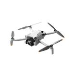


Description
Effective aerial surveying needs to see the invisible. That's why Mavic 3 Multispectral has two forms of sight. It combines an RGB camera with a multispectral camera to scan and analyze crop growth with total clarity. Agricultural production management requires precision and data, and Mavic 3M delivers both.
-
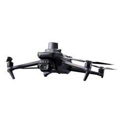
Highly integrated imaging system
Newly upgraded imaging system with one 20MP RGB camera and four 5MP multispectral cameras (green, red, red edge, and near infrared). Enables applications such as high precision aerial surveying, crop growth monitoring, and natural resource surveys. -
Sunlight sensor
The built-in sunlight sensor captures solar irradiance and records it in an image file, allowing for light compensation of image data during 2D reconstruction. This results in more accurate NDVI results, as well as improved accuracy and consistency of data acquired over time. -
Accurate images that capture every pixel
Mavic 3M with RTK module for centimeter-level positioning. Flight control, the camera, and the RTK module sync in microseconds to accurately capture the location of each camera's imaging center. This enables Mavic 3M to do high-precision aerial surveying without using ground control points. -
Orchard mapping
Mavic 3M allows terrain-follow aerial surveying of orchards, even on sloped landscapes. Together with DJI Terra or DJI SmartFarm Platform to reconstruct high-resolution orchard maps, automatically identify the number of trees, distinguish trees from other obstacles or objects, and generate three-dimensional operation routes for agricultural drones, making operations safer and more efficient. -
Intelligent field scouting
The Mavic 3M can carry out automatic field scouting. The field scout images can be uploaded to the DJI SmartFarm Platform in real time through a 4G network. It can find abnormalities, such as emergence deficiencies, weed pressure, and crop lodging in a timely manner. It can also conduct intelligent analyzes, such as cotton seedling identification and rice production testing, using AI identification for real-time sharing of crop growth information, guidance of agronomic activities, and easy management of 70 hectares of farmland by one person. -
Environmental monitoring and natural resources survey
The Mavic 3M can also be used in environment and natural resource surveys, such as water enrichment monitoring, forest distribution surveys, urban green area surveys, and more.
Specifications
Summary
- Product Description
- DJI Mavic 3 Multispectral - Aircraft
- Product Type
- Aircraft
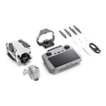
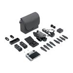
- Included Items
- Carrying case, charger, screwdriver, 3-Axis gimbal, intelligent flight battery, USB-C cable, 3 pairs of propellers, DJI RC remote controller, USB-C to USB-C cable
- Category
- Vehicles - drones
- Camera
- Included - 20 Megapixel
- Max Speed
- 15 metres per second
- Navigation
- GPS/GLONASS/BeiDou/GALILEO receiver
- Interface
- Bluetooth, Wi-Fi
- Outdoor
- Yes
- Width
- 28.3 cm
- Depth
- 34.75 cm
- Height
- 13.96 cm
- Weight
- 951 g
Detailed Specification
General
- Product Type
- Aircraft
- Included Items
- Carrying case, charger, screwdriver, 3-Axis gimbal, intelligent flight battery, USB-C cable, 3 pairs of propellers, DJI RC remote controller, USB-C to USB-C cable
- Category
- Vehicles - drones
- Size
- 380.1 mm
- Remote Control
- Yes - 5.8 GHz - max operating distance: 15 km
- Power Source
- Battery
- Outdoor
- Yes
- Max Speed
- 15 metres per second
- Supported Flash Memory Cards
- microSDHC, microSDXC up to 512 GB
- Features
- Obstacle avoidance system
RC Vehicle
- Take-Off Weight
- 1050 g
- Vertical Hovering Accuracy
- +/- 0.1 metres
- Horizontal Hovering Accuracy
- +/- 0.3 metres
- Max Angular Velocity
- 200° per second
- Max Tilt Angle
- 35°
- Max Ascent Speed
- 8 metres per second
- Max Descent Speed
- 6 metres per second
- Max Wind Speed Resistance
- 12 metres per second
- Navigation
- GPS/GLONASS/BeiDou/GALILEO receiver
- Interface
- Bluetooth, Wi-Fi
- Wi-Fi Bands
- 2.4 GHz, 5.8 GHz
Gimbal
- Control Angle Range
- -90 to 35° (pitch)
- Max Speed
- 100° per second (tilt)
Digital Camera
- Sensor Resolution
- 20 Megapixel
- Image Sensor Type
- CMOS
- Focus Adjustment
- Manual
- Capture Formats
- MP4 (MPEG-4 AVC/H.264)
- Video Recorder Resolutions
- 1920 x 1080 (1080p) 30fps, 3840 x 2160 (4K) at 30 fps
- Still Image Formats
- JPEG, RAW, DNG
- Still Image Resolutions
- 5280 x 3956
- Max View Angle
- 84 degree(s)
Battery
- Rechargeable Battery
- Rechargeable
- Supported Battery Configurations
- 4S
- Technology
- Lithium cobalt oxide
- Voltage
- 15.4 V
- Capacity
- 5000 mAh
- Run Time
- Up to 43 min
Miscellaneous
- Compliant Standards
- 802.11ax, Bluetooth 5.1
- Dimensions
- 34.75 cm x 28.3 cm x 13.96 cm
- Weight
- 951 g
Choking Hazard Warnings
- Dimensions & Weight Details
- Folded without propellers - 9.63 cm x 22.3 cm x 12.22 cm , Unfolded - 28.3 cm x 34.75 cm x 13.96 cm , Battery - 335.5 g
Environmental Parameters
- Min Operating Temperature
- -10 °C
- Max Operating Temperature
- 40 °C
